The original time zone was a subdivision of 15 ° (degrees) wide tracks in the earth's
longitudinal direction, which corresponds to approx. 1 hour at the equator, but as shown by the map
the time zone limits is change a lot by national and political reasons.
Mouseclick the map to get the local time at that location.
Important:
All time calculations are based on your computer's clock relative to UTC (Universal Coordinated Time),
formerly known as GMT (Greenwich Mean Time) and without consideration of any local DST calculation, since the start
and end at summer time can be varied and it also depends of each country or state.
Some have never used the summertime, and others gone away from it again.
It is only the button with the local time on the Time Zone page that displays the time including any DST calculation,
if summer time is updated on the computer!
 Some metropolitan local times are shown at the top of the page. It is easy to see the weekdays there.
 There is included a day-night scale which is adjusted every hour, and displays the current local
time in relation to the card. Day and night are each set to 12 hours, the Date Line is between 23
and 24, it should be read so the field with 23 matches with Kl.23:00-24:00 and field
number 24 to Kl.24:00 - 01:00. 24:00 and 00:00 are the same time.
There is included a day-night scale which is adjusted every hour, and displays the current local
time in relation to the card. Day and night are each set to 12 hours, the Date Line is between 23
and 24, it should be read so the field with 23 matches with Kl.23:00-24:00 and field
number 24 to Kl.24:00 - 01:00. 24:00 and 00:00 are the same time.

|
There are used different colours for alternating the display of time zones. One set consists of:
Blue, Grey and Green. The blue is the ocean, gray and green are the country where green indicates
that the time is delayed 30 minutes compared to the time zone. The same applies to the second
set of colours, Aqua, White, Yellow and Orange where the yellow indicates a time difference of 30 minutes and the
orange a difference of 15 minutes. The red dots on the map indicate the city names listed in the yellow boxes at the top of the page.
|
The numbers 1-24 at the bottom of the map corresponds to the days 24 hours.
The letters at the top of the map indicates the military's time zone
division and is pronounced with the phonetic alphabet.
(See: Time Zone Table )
Clicking on the map or city buttons opens a new window that shows local time at that
location. The window can be resized and placed anywhere on the screen to continuously showing
information about the selected local time. This also applies to Time zone page. The page code is
client-side, which means that the it is running locally independent of the server.
The connection to the Internet is only needed when the page opens.
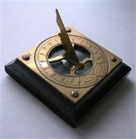
Pocket sundial with built-in compass.
Calculation and classification of time has always been important for people in connection with the changing of seasons
for fishing, hunting, agriculture, astronomy and maritime navigation.
The sundial is the first known clock to measure time. In its simplest form it is a shadow from a stick in the ground
when the sun shines on it, thus giving Sola time. In the middle of the day when the shadow is shortest it is 12 oclock.
There are two solar times: solar time (true solar time) and middlesolartime. Solar time, however, has several disadvantages,
it is only on the same longitude solar time can be directly compared, across longitudes time
will be different, it can only be 12 one place at a time. In Denmark there is a solar time difference from Bornholm to the
North Sea of approx 30 minutes.
Due to development through the years, the requirement for the measurement and standardization of time has become
larger and larger, only a few of them are mentioned on this page.
The development of instruments and computers has also improved and now allows calculation results with several decimal places.
Through the ages there has been used and invented and many different kinds of clocks and watches: water clocks,
hourglasses (sand clocks), mechanical watches, electronic watches, etc. Automatic watches are the most accurate, the
latest loose only 1 second in 300 million years.
|
Longitude:
Longitude also caled meridian are lines that runs true the poles and divided the earts circumference degrees, minutes and seconds.
1 degree equeal 4 mimutes and 15 degree one houer, the basic for time zone. Longitude 0 adopted in 1884 see GMT.
Solar time:
True solar time is the time when the sun is highest in the sky and the time spent before it does it again. This period
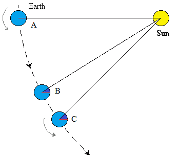
of time is a solar day, but solar days have variable lengths, one reason is the earth's tilting another is the planet's speed
around the sun, it varies and is faster (A-C ) when the earth is closer to the sun than when it is (A-B) furthest away.
Also the earth's rotation about its own axis is not constant the rotations is slightly longer for C than at B, before the
sun again shines highest in the sky and it is midday. Variation on an annual basis is about. + / - 15 minutes.
Middlesolartime:
With the introduction of middlesolartime a day was set to (24 hours) the average length of a day during the year.
This meant that the variable length of the day, now is the time between 12 oclock and the middle of the day when the sun is highest
on the sky.
This variation is small compared to the national time zones, where time and distance, in some countries between 12 oclock and the middle of the day is many times larger.
|
Mean time:
After the introduction of the railroad in the first half of 1800 century, in England it was decided to use mean time
as to have the timetables to work. The place for mean time was Greenwich Observatory.
Denmark later had the same problem with train timetables; in 1877 it was decided to use Copenhagen as a
starting point for the mean time.
GMT:
Greenwich Mean Time. Since 1884 the prime meridian, longitude 0 or Greenwichmeridianen
passes through the Greenwich Royal Observatory, Greenwich. For a long period of time GMT was the basis for division into
time zones and refers to solar time, GMT has since been replaced by UTC which is more accurate.
UTC:
Universal Time Coordinated. Basis of UTC is atomic clocks that continuously adjust with a leap second to match the
Earth's rotation. UTC is the basis for all other time calculations. Time zones around the earth calculated with
easterly (+) or west (-) direction from UTC.
TAI:
Temps ATOMIC International. Is entirely based on atomic clocks and is used primarily in science, the advantage is that
TAI time can be compared directly without calculation of leap seconds. Since 1972, TAI is used as the basis for UTC.
UT1:
Stands for: Earth rotation time-of-day. The time it is measured as a fraction of Earth's daily rotation.
UT1 time as compared to International Atomtid TAI, not what time is measured with an atomic clock.
Z or Zulu time:
Zulu is the phonetic word for Z. Zulu time is the same as UTC and is used mainly by the military to uniform
time for joint operations. In fact, all the time zones include a letter based on the phonetic alphabet.
NTP:
Network Time Protocol. NTP is used on computers to synchronize the internal clock with a networks server which is part
of an international network hierarchy of servers, at the top are some extremely accurate atomic clocks. The different
layers of servers communicate with each other and constantly adjusts the time.
Atomur:
Atomic clock consists of chilled (ca.273 Celsius) gas atoms trapped in a magnetic field. The pendulum are the electrons
swing in their orbits around the atomic nucleus. Atomtid see: TAI.
Protokol (Protocol):
In computer terms are protocols a set of rules that allows multiple devices to communicate together.
Here are additional explanations for time zones:
U.S. Naval Observatory
Geodetic Research Laboratory
World timezone
Time and Date
Maps of world
World atlas
Eric Weisstein's World of Science
|